
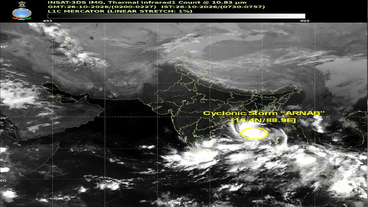
A cyclone has been clearly formed in the Bay of Bengal. The latest cyclone Arnab update says that it is likely to intensify into severe cyclonic storm on October 27.
The deep depression took the form of a cyclone at 5:30 am today. It will intensify into a severe cyclonic storm by tonight. Cyclone Arnab will intensify into a very severe cyclonic storm tomorrow.
Landfall is likely between Bapatla-Visakhapatnam on October 28. The latest Cyclone Arnab update says that it is likely to make landfall 300 km away from Gopalpur. If the path and intensity of the cyclone changes, the estimate of its impact on Odisha may also change.
According to the Indian Meteorological Department (IMD), it has been moving at a speed of 15 km per hour in the last 6 hours. The landfall location is estimated to be about 300 km away from Gopalpur in Odisha.
Likely Impact Of Cyclone Arnab
Due to the impact of the cyclone, heavy to very heavy rain and gusty winds are expected in various parts of the state.
According to the warning of IMD, very heavy rain is likely to occur in some parts of the state tomorrow. Extremely heavy rain on the October 28 and on October 29. The impact of rain is likely to be more severe especially in Ganjam, Gajapati, Rayagada, Koraput and Malkangiri districts.
There is a risk of waterlogging in the low-lying areas and landslides in the hilly areas. Given the possible path of the cyclone, its impact may be felt more in southern Odisha. Heavy rain and gusty winds may occur in Gopalpur and Berhampur. The sea will remain rough.
The cyclone may also have an indirect impact in Bhubaneswar and Cuttack. However, the direct impact of the cyclone is likely to be less in these two cities as compared to South Odisha. The wind speed may be 115 to 125 km per hour when the cyclone crosses the Andhra Pradesh coast.
State Government In Complete Preparedness
Keeping in view the possible impact of the cyclone, the state government has intensified preparations. About 60 ODRAF teams, 17 NDRF teams and 225 fire service teams have been deployed to deal with it.
It has been decided to keep schools, colleges and anganwadi centers closed on October 28 and 29 in the 5 districts of South Odisha that are likely to be affected. Cyclone shelters are being kept ready and arrangements are being made to shift people to safer places in case of emergency.
The leave of the concerned officials has also been cancelled. People of South Odisha are advised to be especially alert and follow the instructions of the Meteorological Department and the district administration.
The #Deep #Depression over Eastcentral and adjoining Southeast Bay of Bengal moved nearly westwards with a speed of 15 kmph during last 6 hours, intensified into #cyclonic storm “#Arnab” [Pronunciation :#Ornab]” and lay centered at 0530 hrs IST of today, the 26th October, 2026 over Eastcentral and adjoining Westcentral #Bay_of_Bengal near latitude 15.4°N and longitude 88.9°E, about 590 km northwest of Sri Vijaya Puram (#Andaman Islands), 610 km southeast of Gopalpur (Odisha), 650 km east-southeast of Vishakhapatnam (Andhra Pradesh), 730 km east-southeast of Kakinada (Andhra Pradesh), 830 km east of Machilipatnam (Andhra Pradesh) and 910 km east of Bapatla (Andhra Pradesh).
It is very likely to move west-northwestwards and intensify further into a severe cyclonic storm over westcentral Bay of Bengal by midnight of today, the 26th October and into a very severe cyclonic storm over the same region on 27th October.
Thereafter, it is very likely to move northwestwards and cross #Andhra_Pradesh & #Yanam coasts between #Bapatla and #Visakhapatnam as a very severe cyclonic storm with the maximum sustained wind speed of 115-125 kmph gusting to 140 kmph by forenoon of 28th October, 2026.— India Meteorological Department (@Indiametdept) October 26, 2026